





What Is TRNAV? TUALCOM’s Satellite-Independent National PNT System

TRNAV is a national positioning and timing system developed by Turkish defense electronics company TUALCOM that operates fully independently of satellites. In environments where GPS and other GNSS signals are jammed, spoofed or cut off entirely, it produces precise position and time data over a network of ground stations. The company announced in 2024 that the system was ready for all platforms. TRNAV is among the first comprehensive national PNT (positioning, navigation and timing) solutions aimed at reducing Turkey’s dependence on GNSS.
Why was TRNAV developed?
Nearly all modern military operations depend on position and precise time data, and the primary source of that data — GNSS satellites — is fragile against electronic warfare. Satellite signals reach the ground extremely weak and can be cut by relatively simple jammers. Widespread GPS jamming around the Black Sea and the Middle East in recent years, affecting even civil aviation, has amplified the need for satellite-independent backup navigation. The United States, South Korea and several European countries run terrestrial PNT programs on similar grounds.
How does TRNAV work?
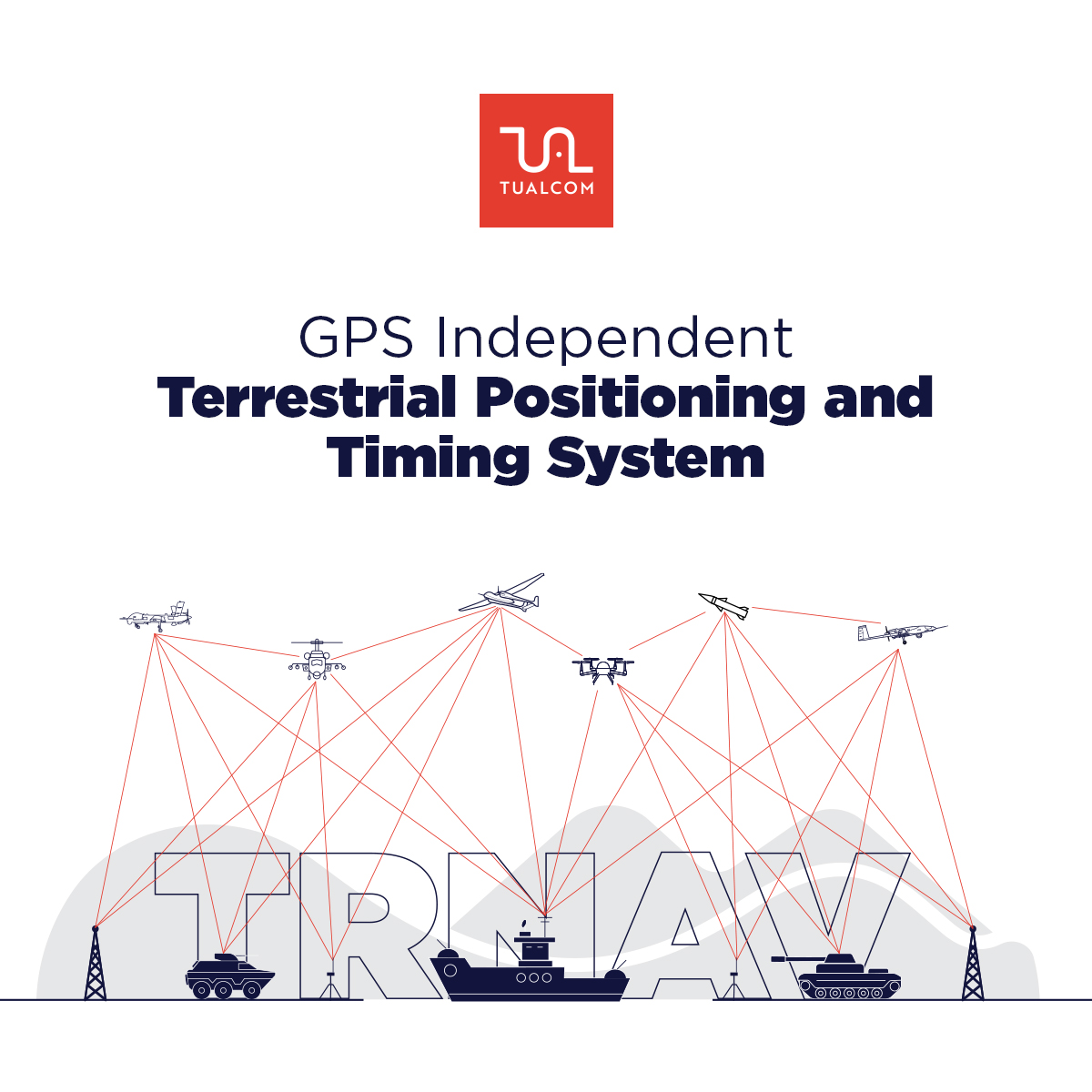
According to the company’s official literature, TRNAV operates over a mesh network formed by ground stations whose positions are precisely surveyed:
- The ground stations can synchronize with satellite signals while GNSS is available; when GNSS is cut, they continue operating independently using their pre-surveyed precise positions.
- A user platform can compute its position with near-GNSS accuracy by connecting to at least three ground stations.
- The system’s highly synchronized timing infrastructure drifts on the order of 10 nanoseconds over one week without GNSS.
- TRNAV signals also serve as a data link; the stations have multi-node communications and networking capability.
According to the company, the system’s high computation rate makes navigation on high-speed platforms more effective than GPS/GNSS.
What sets TRNAV apart from GPS?
| Feature | GPS/GNSS | TRNAV |
|---|---|---|
| Signal source | Satellite constellation | Terrestrial ground station network |
| Coverage | Global | Regional (the area covered by the station network) |
| Jamming resistance | Weak signal, fragile | Strong terrestrial signal; designed for jamming environments |
| Sovereignty | Foreign state control (GPS: United States) | Fully national infrastructure |
| Timing | Atomic clocks, delivered from satellites | Drift of ~10 ns per week without GNSS (company figure) |
| Additional function | – | Can also operate as a data link |
Who uses it?
The company does not publicly disclose TRNAV’s users or any delivery contracts. Official presentations in 2024 stated that the system was ready for all land, naval and air platforms. The system has also been covered by GPS World, an international GNSS industry publication.

Does it have counterparts?
Global examples of terrestrial PNT include South Korea’s eLoran program, NextNav’s TerraPoiNT system in the United States and various UK-based resilient-PNT ventures. As a satellite-independent, network-based national positioning system, TRNAV is among the first publicly announced solutions of its kind in Turkey. TUALCOM’s GNSS-side protection product, the TUALAJ family, and TRNAV form two complementary layers: TUALAJ protects the existing satellite signal, while TRNAV provides an alternative when the signal is lost entirely.
Frequently asked questions
What is TRNAV?
A national positioning and timing (PNT) system developed by TUALCOM that operates independently of satellites.
Who developed TRNAV?
TUALCOM Elektronik A.Ş., based at METU Teknokent in Ankara, developed it entirely with domestic resources.
Will TRNAV replace GPS?
It does not offer global coverage; it provides a backup or alternative navigation layer in regions where GNSS is jammed or cut.
How does TRNAV compute position?
The user connects to at least three ground stations with precisely known positions and computes its own position.
What is TRNAV’s timing accuracy?
Per company data, roughly 10 nanoseconds of drift over one week without a GNSS connection.
Who uses TRNAV?
The company does not share user or contract information; in 2024 it announced that the system was ready for all platforms.
What is the difference between TRNAV and TUALAJ?
TUALAJ protects the satellite signal against jamming; TRNAV is an alternative position source fully independent of satellites.
Has TRNAV’s price been announced?
Not officially disclosed.
Sources and verification note
- TUALCOM official website — TRNAV product page and terrestrial-navigation technical articles (station network, three-station rule, 10 ns timing figure)
- TUALCOM official social media announcements (May 2024) — “ready on all platforms” statement
- GPS World — coverage in the international trade press
Details the company has not disclosed on accuracy, coverage area and users have not been estimated in this article.